|
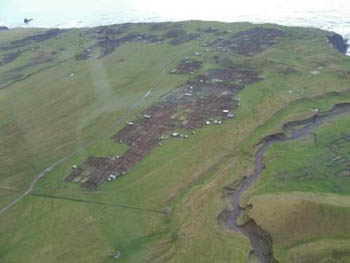
Photographs taken from the helicopter from HMS Richmond on 31st October 2013 |
|
|
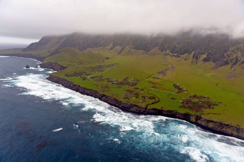
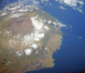
Looking east showing the Potato Patches, Hillpiece with Boatharbour Bay below, the Goat Ridge and the Settlement.
High tide combined with a swell means that Runaway Beach below the low patches cliffs is almost invisible, but the photo highlights the Wash Gulch whose debris-strewn path can be seen meandering across the plain to the cliff and sea below in the centre of the image. |
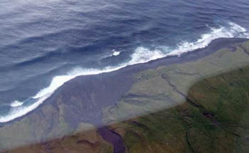
Unusual and striking view looking down to Hottentot Point and across Hottentot Fence and showing Hottentot Gulch right. The 1961 lava flow has been eroded back over 50 years and perhaps there will be a bay here, fronted by a boulder beach in another 50 years? Beyond Big Point as always is forbidding far left with Pigbite in between. |
|
|
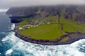
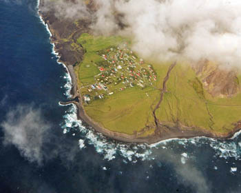
The Tristan Settlement of Edinburgh of the Seven Seas,
with the modern fishing factory and Government Buildings dominating the lower plateau above the harbour
and on the western edge of the village. |
A view looking directly into Calshot Harbour which emphasises
how the 1961 lava flow miraculously left intact
(apart from one damaged roof) the village houses and so enable Tristan Islanders to reclaim their homes by November 1963. |
|
Tristan and Inaccessible from 34,000 ft on 23rd March 2011 |
|
|
Photographs taken from 34,000 ft on board a
South African Airbus 340 flight from Johannesburg to Buenos Aires on 23rd March 2011 by Senior Purser Rosslyn Milella. |
Image of Tristan da Cunha published in large format in the February 2012 Tristan Newsletter.
The Ponds (three explosion crater lakes) can be clearly seen lower left. The photo offers a very good south-west view along the Settlement Plain which disguises Hillpiece so giving the impression of a continuous lowland plain of 5 miles (7 kilometres).
Queen Mary's Peak is remarkably clear and there is a good view top right of The Base between Burntwood and Green Hill. |
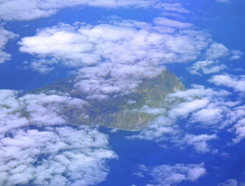
Image of Inaccessible Island partially seen through cloud well above the island's plateau. The photo was taken two minutes after the Tristan shot opposite. The Editor thinks that the view is looking south, with Blenden Hall, Skua Bog and West Point just visible through the cloud far right and the cliffs visible centre are Warren's Cliff / North Point, with Salt Beach further left partly obscured by cloud.
|
Photographs from HMS Endurance's Helicopter taken on 12th April 2007 |
|
|
Taken from the North-East showing ~
Foreground : Rookery Point & behind The Ponds
Far Left : Sandy Point
Far Right : Hottentot Point & The Settlement
Between Rookery Point & Hottentot Point ~
note the distinct promontory of Big Point
and beyond Pigbite and the black 1961 lava flow
|
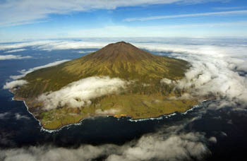
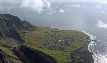
Taken from the North-West showing ~
Foreground: Boatharbour Bay and Hillpiece (obscured by cloud)
Foreground left: Hottentot Point and The Settlement
Foreground right: Patches Plain
Behind the Patches Plain Tristan's highest cliffs rise sheer over 1500m
towards Nellie's Hump and the Stone Castle
|
|
|
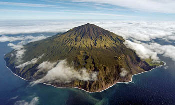
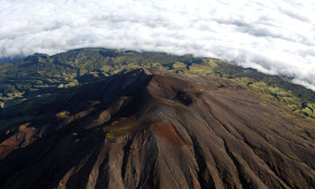
The 2060 m ~ 6760 ft Queen Mary's Peak from the NNE
The heart-shaped summit crater is visible below The Peak,
with Church Rock to the right
A ridge runs south from The Peak to Mount Olav
Visible in the distance left is Caves Gulch Hill
and to its right Soggy Plain and Green Hill
Note the contrast between the grey bare volcanic ash of the peak cinders, with only a sparse covering of lichens and mats of island berry
and the green of the lower base, clothed in dwarf tree ferns and the island trees. |
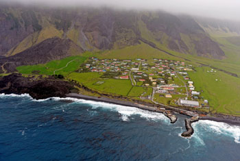
Vertical view above Hottentot Point showing also ~
The dry course of Hottentot Gulch
Far Right: Crawford Point and above The Goat Ridge
Centre : The Settlement of Edinburgh of the Seven Seas
with the White roofed Fishing Factory above Calshot Harbour
Top Left : The black 1961 lava flow |
Photographs taken by David Morley from the SA Agulhas Helicopter on 3rd October 2007 |
|
|
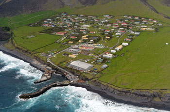
View from the east :
Showing the Tristan Settlement
with the 1961 Volcanic cone and lava flow in front
and The Goat Ridge back left
|
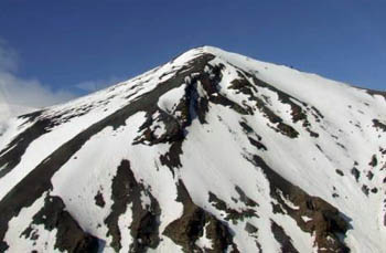
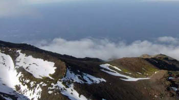
Typical mountain ridge
ridges radiate from the central peak
sloping from the snow-covered stony upper slopes
towards the
lower base slopes
|
|
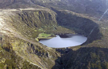
The Top Pond
Smallest of the three Ponds - these features are unusual explosion craters, now linked by flowing streams which form depressions in the gently sloping north-eastern part of the base.
There are five other crater lakes on the Tristan mountain, all within conventional raised volcanic parasitic cones known as parasitic cones, as well as the summit crater lake, making 9 in total
Typically all lakes on Tristan are locally known as Ponds. |
Photographs taken by Factory Manager Erik McKenzie
from HMS Southampton helicopter on 30th October 2007
|
|
|
Queen Mary's Peak
with an alpine appearance |
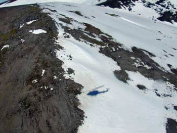
SA Agulhas' helicopter's shadow
shows up on a summit ridge snowfield
|
| |
|
|
View above the Molly Gulch ~
showing its delta forming a slight promontory.
Also visible is the Administrator's Camping Hut (centre picture)
some 7 kms from The Residency.
Far Left is near The Bluff, where Tristan's main road
(here only a rough track) comes to an end on its route
from The Settlement via The Potato Patches. |
View of the Potato Patches ~
showing Big Sandy Gulch (right)
far top right a glimpse of the cliff above Boat Harbour Bay
and bottom right the slopes of Burnt Hill |