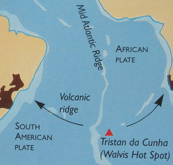
Tristan TectonicsThe Atlantic Ocean began to form when the African and South American plates were thrust apart about 120 million years ago. Ocean floor spreading continues at the Mid-Atlantic Ridge where relatively shallow rising magma erupts into basalt lava forming low ridges on the ocean floor, pushing Africa north-eastwards and South America north-westwards at a current rate of about 2cm a year. Tristan da Cunha is not on the Mid-Atlantic Ridge but is a surface expression of a deep-seated hot spot some 400 km east of the ridge (see map right). Hot spots (The Hawaiian Islands are another example) such as these receive magma from deep in the earth's mantle. |
|
|
|
|
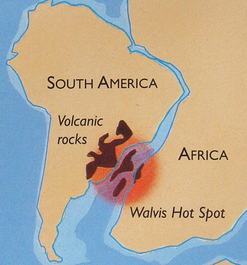
| The Walvis Hot Spot and volcanic rocks deposited in modern South America and Africa as the continents were thrust apart | The current tectonic situation with the submarine Mid-Atlantic Ridge and Tristan da Cunha as the active end of a mainly submarine and extinct volcanic Walvis Ridge. |
|
The Tristan Island Group forms the modern south-west end of a range of otherwise extinct submarine volcanoes, termed seamounts or guyots ( former volcanic islands now planed off by sea erosion) known as the Walvis Ridge. This largely submerged mountain range marks the movement of the African Plate north-east over the stationary hot spot. As the ocean floor spreads, the fixed hot spot leaves a trace-line of volcanoes, each of which becomes extinct as it moves away from the stationary mantle source. Eventually, as the African plate moves further NE, Tristan itself will become extinct and a new active hot spot volcano will build to the west. The present-day Tristan Island Group marks the hotspot activity during the last 18 million years, first forming Nightingale Island (an extinct remnant in the latter stage of erosion), then Inaccessible Island (a younger extinct cone in the middle stage of erosion) and finally Tristan island itself (having the classic conical shape of an active shield volcano). |
|
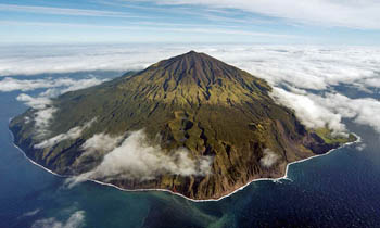 |
The Tristan VolcanoTristan da Cunha is an active strato-volcano formed above a magma hot-spot some 400km east of the Mid-Atlantic Ridge. The volcano first erupted 3 million years ago from the 3500m deep ocean floor. Successive eruptions have built a cone 48km wide and 5500m high, with the summit (Queen Mary's Peak at 2,060m above sea level) overlooking a heart-shaped crater lake. Tristan erupts both effusively (to form sheet-like lava flows) and explosively (when magma has a higher gas content to yield ash and vesicular rocks like the recent pumice). Vesicular rocks are those with many cavities or holes and are commonly called 'floating stones' on Tristan. The Tristan volcano has many parasitic cones on its flanks, each representing a separate eruption of the main volcano. Stony Hill erupted in c1750 producing an extensive black lava field on the southern part of the island. In 1961 the Settlement on the north western plain was threatened by an eruption which destroyed the crawfish factory and the island's two best landing beaches, leading to the temporary evacuation of the entire population to England. In 2004 an undersea eruption 24km southeast of Stony Beach produced blocks of pumice which were retrieved by Tristan fishermen as they floated to the surface from an epicentre 3000m below. The Settlement was shaken by tremors and bags hurriedly packed, but the precautionary evacuation plans remained theoretical. |
|
Photos above and below from HMS Endurance's Helicopter taken on 12th April 2007 Above: Taken from the North-East showing: Note: Between Rookery Point & Hottentot Point - |
|
 |
|
|
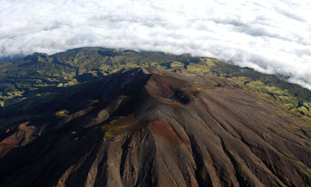
The 2060m - 6760ft Queen Mary's Peak from the NNE
The heart-shaped summit crater is visible below The Peak, with Church Rock to the right. A ridge runs south from The Peak to Mount Olav. Visible in the distance left is Caves Gulch Hill and to its right Soggy Plain and Green Hill. Note the contrast between the grey bare volcanic ash of the peak cinders, with only a sparse covering of lichens and mats of island berry and the green of the lower base, clothed in dwarf tree ferns and the island trees. |
To be continued |